So, You Think You Love Horses?
Some Reflections on the Nature of Horses and Man
More Discussions by The Accidental Horseman
Horseback Riding at Union Mills Area (Southern Section)
Near Westminster, Maryland
Notice: As of Spring 2019 I understand that portions of this trail was washed out and the trail closed to horse traffic. I am uncertain as to future plans and have not walked the trails to check their condition on the ground.
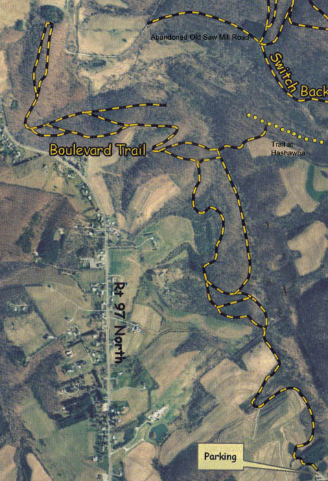
Master Map of Southern Equestrian Trails Union Mills Area
Near Westminster, Maryland
(Modified from Map of Carroll County Department of Recreation and Parks)
|
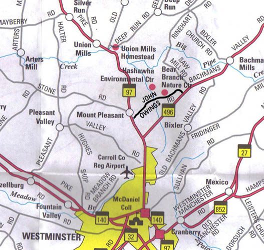
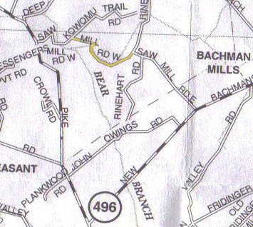
Map of Local Roads
John Owings Road in Bold
|
| 
|
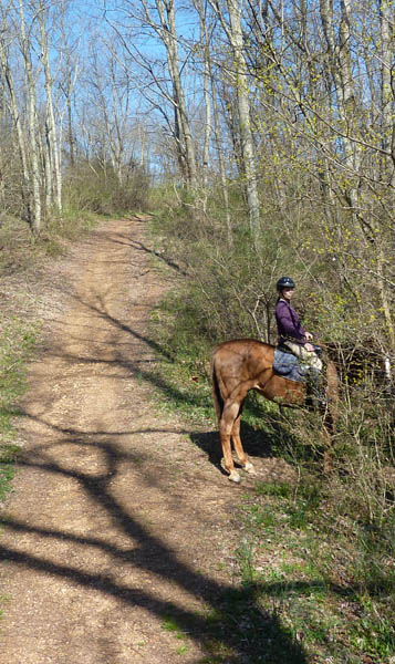
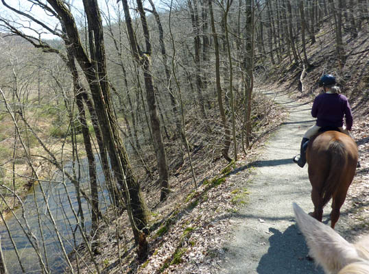
Union Mills is a county recreational area located in Carroll County, Maryland off of Route 97, north of Westminster, Maryland. It is a great place to visit for trail riders living in north central Maryland or southern Pennsylvania. It features over 8 miles of equestrian trails that are mostly in woodland. Many of the trails are old access roads or have been blazed through woodland. The trails are easy on horses' feet with only a few sections that are rocky or washed out. There are also a few spots were small streams cross the trails, and areas can be muddy in wet weather. Motorized vehicles are not permitted on these trails, but be alert for mountain bikers or dog walkers. They are generally very courteous to horseback riders, but once we were surprised by a cyclist around a blind curve. Hunting is allowed on Monday, Wednesday and Friday during hunting season and everyday except Sunday during rifle season. There are occasional signs, set on steel pipes along the trails, marking them. There are also pink blazes painted on trees along the path. However, for the most part they are unnecessary because the trails are obvious. Parts of the trail network at Union Mills are narrower than I would like and many run along hillsides. Most of them cannot be maintained with any kind of power equipment. This gives then a rustic quality but watch out for those multiflora rose.
One comment about the Union Mills County Recreational Area is that the boundaries of the parkland are not all that well marked. I generally follow paths that prior riders clearly have used and respect any posted no trespassing or no horses signs. Many of the trails are old abandoned dirt roads or lanes for which rights of way must exist even though they pass along, or maybe even through, what appears to be private property (either as shown on maps or when seen in person on the ground). However, I have never been approached by anyone claiming to be a property owner with a complaint. The entire area is rather wild and undeveloped and you are unlikely to see a soul when riding there.
Union Mills Recreational Area can be divided into three separate areas which are connected. The three areas are serviced by two parking areas. The southern parking area is located off of John Owings Road. The more northern parking area is off of Kowomu Trail Road and serves the northern trails and also the eastern trails (Spiegle Hill trails). In this particular discussion, I will focus the southern parking area and trails only.
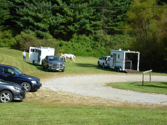
Southern Parking Area Between the Ponds
|
|
The southern parking area is reached by turning onto John Owings Road from Maryland State Route 97 that runs between Westminster, MD and Littlestown, PA. When headed north from Westminster, it is a right turn at the bottom of a hill. If headed south on 97, it is a left turn just past the Carroll County Sports Complex. Once on John Owings Road it is a left turn into the parking area.
The southern parking is located between two small ponds and is at the bottom of a hill. It is marked with signage but has a very limited parking capacity. You might be able to fit a total of six typical horse trailers in the area with some effort. There is a crushed stone roundabout, but the parking is on grass and in wet or icy weather the area should be avoided. Two or three trailers can be parked between the ponds comfortably. Other trailers might be parked along the roundabout or a narrow flat area down from the side of the roundabout if you handle backing a trailer into tight spots well. I have never gone there and had no place to park but do not plan to launch a large group ride from this area.
If you are a first time equestrian visitor, I now will take you on a virtual tour of the trails. Once you off-load at the parking area you will discover the entrance to the trail when looking north and away from the road on the left side of a pine woods beside the upper pond.
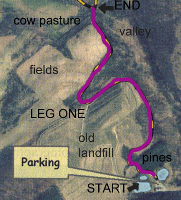
LEG ONE
Leg One Map
|
|
|
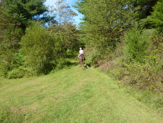
Leg One: Entering the Southern Trails
| |
Going Uphill on the Side of the Old Landfill
|
| 
|
You ride up a rise and walk through the pines a short distance and then leave the pines and curve to the left, walking along a hillside. To your left and above you is the former Northern Landfill of Carroll County. Under that land is the remains of generations of trash, and sampling well heads can be seen along the edges of the now closed dumping site. To your right and downhill is Hashawha and the Bear Branch Nature Center. The Hashawha Environmental Center is a public residential retreat center owned by Carroll County. It the site of an outdoor school and also is popular with hikers. You will often see or hear children or others who are in the park down the hill. Only a small number of Hashawha trails are open to horseback riding and not in this area. After you leave the pines you are walking along a flat trail built into a steep hillside and then bearing left and going slightly uphill. Drainage from the hill has created some wet areas and ruts in the trail in this area.
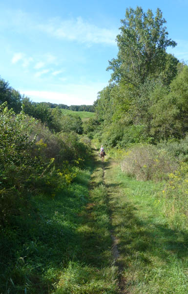
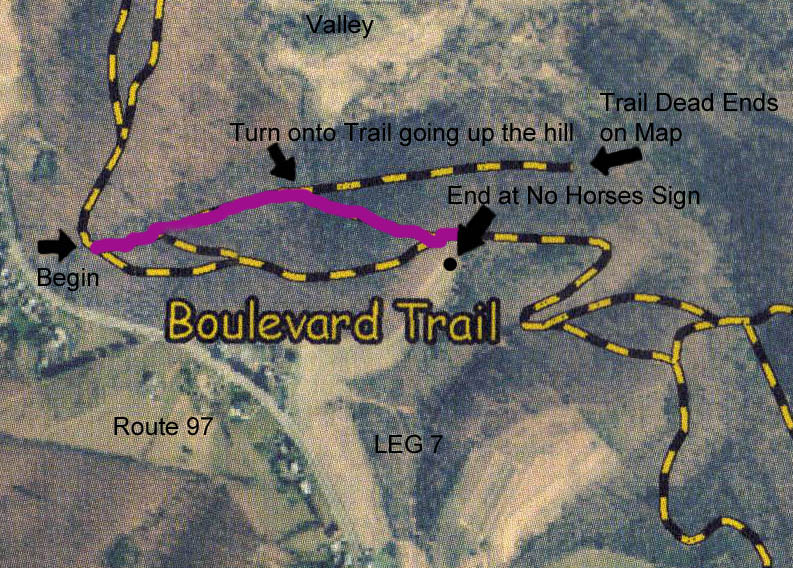
Once at the top of the rise you make a sharp right turn. The trail flattens out, and there is a field to your left and a wooded valley to your right. After you continue a fairly short distance, the trail begins to descend, and you make a turn to your left along a field on the left. On your right is a wooded slope and more of Hashawha. Once you finish this stretch, the trail makes a sharp drop down the hill and curves to the left over a buried culvert and small stream coming from a cow pasture to your left. When you cross the culvert you will see that there is a small trail coming in from your right. If you would go straight there is a wide trail heading uphill, and this trail is called the Boulevard Trail and is the major trail in the southern area of the park. The Boulevard Trail is nice and wide throughout its length and goes up and down hills. However, at a couple points it has particularly steep grades and is badly washed-out. The Boulevard Trail is worth knowing as a landmark and runs from the John Owings Road parking lot all the way to West Saw Mill Road at the northern end. However, there is also another network of more narrow trails that roughly parallels the wider Boulevard Trail, and we are going to take you on these now. They lack the rocky, washed out stretches of the Boulevard Trail, but their major limitation is that they are narrow. It is always a problem to meet riders coming from the other direction on these trails. Fortunately, that is a rare occurrence.
Cow Pasture at turn into Lower Trails

|
|
|
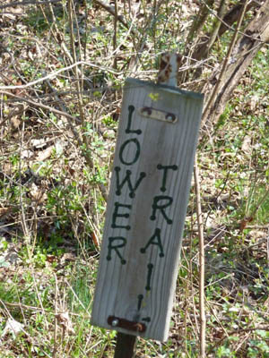
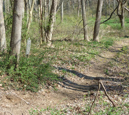
Lower Trail Sign
|
|
|
Turn into Lower Trails
Boulevard Trail continues uphill.
|
|
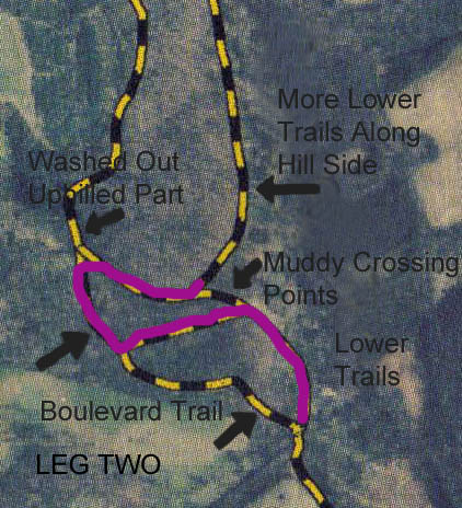
LEG TWO
Leg Two Map
|
|
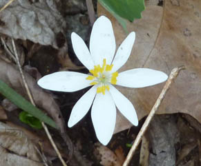
When you cross the culvert you will see that the main trail Boulevard Trail goes rather steeply uphill at this point. Just before the uphill stretch there is a small trail marked with a sign reading Lower Trail, that opens to your right. Turn into this trail and follow it around as it curves left and then runs uphill and levels out as a narrow trail running parallel to but downhill from the main Boulevard Trail. This trail continues through woods for a distance and finally ends at a small streamlet. There are three ways to proceed at this point in order to cross the ditch of the streamlet. Slightly off to the right is a small trail that crosses through a very short swampy stretch. Its not too bad. If you cross here, turn towards the left at an intersecting trail once you get across the small stream and muddy area. The second way to cross I generally avoid is a very steep bank going over the streamlet. You come to this second crossing if you continue a short distance curving to your left from the point you saw the first crossing. However, I am picking the longest way and this involves continuing on a fairly overgrown trail that is parallel to the streamlet and ends in the Boulevard Trail. When you get out of this trail you will turn right on the Boulevard Trail and go only a short distance. Using this route you cross over a culvert and avoid having to cross water or mud. Now you are at the bottom of the worst uphill and eroded stretch of the Boulevard Trail. However if you turn right there is a trail that goes back to a point on the other side of the ditch from where you had been, and that is what we will do. When you get to that point, there is a trail intersecting on your left. You will turn onto that. The trail you were on continues beyond this for a short distance to pick up that first crossing point that I mentioned, and then it continues on to disappear somewhere out on the Bear Branch flood plain. At one time this was a meandering trail that reentered the Lower Trail farther up the path, but it has not been maintained and is now totally overgrown. For the naturalist among you (I have been told) that the Lower
Trails are home to the perennial wildflower (Sanguinaria canadensis), known as the "Blood Root." I have noticed these ground hugging, often solitary, white wild flowers along the trail, but do not become to fond of them because the roots really are poisonous.
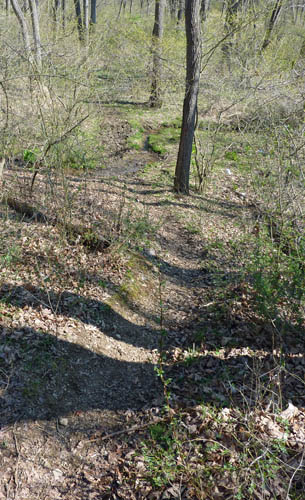
Too Muddy First Crossing Point
I am passing it.
|
|
|
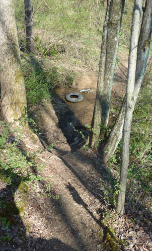
Too Steep Second Crossing Point
The tire is a nice touch.
|
|
|
Blood Root Flower
Photographed by the trail
|
|
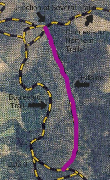
LEG THREE
Leg Three Map
|
| 
|
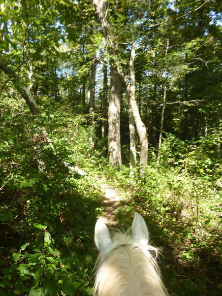
The trial here is very narrow.
|
|
This part of the Lower Trail is a problem. The path is right along a fairly steep drop and is very narrow. In wet weather the bank might be soft and give away. You may have noticed that a horse has four legs and generally if this happens you still have three of them on terra firma. I would not do this stretch on a horse that I lacked confidence in. After a short stretch it becomes wider, and you might be forgiven if you let out a sigh of relief. Trail riding is not for the faint of heart. Many riders are of the opinion that this short stretch should not be taken on horseback at all. If this worries you, I should mention that there is a second, newer bypass trail that has been blazed to your left that avoids this hillside, but it is not well established and has some steep grades. The two routes merge after a short stretch so you might do either. The trail continues running along the hillside and comes to one fairly steep drop. This drop is well carved-out from years of use, and I have never had any problems doing this. It is a noticeable feature, so I mention it. When you get to the bottom the trail is only a little higher than the flood plain of Bear Branch. The trail is narrow, and if your horse has a talent for running your knee into a tree, along here is where it will happen. The trail finally widens, and you at last come to a junction of several trails and the end of Leg Three.
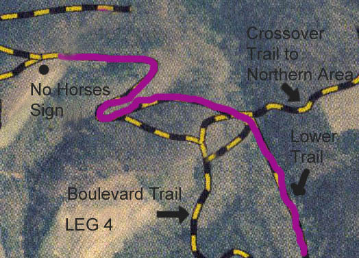
LEG FOUR
Leg Four Map
|
|
When you come to the junction there are several trails heading in different directions. The first one you come to is on your left and is a short trail that runs back to the Boulevard Trail. This trail is useful because it allows you to leave the Boulevard Trail and avoid that particularly steep and washed out section that I mentioned as the worst stretch of the Boulevard Trail. If you go or come using this stretch of trail you can either drop down to the lower trails, or from the lower trails you can move up and pick up the Boulevard Trail and continue on that. However, for our tour I am not going to go on this connecting trail at this point.
Looking to your right and just a short distance down the trail, you will see a second trail and this one heads off toward Bear Branch. There is a sign marking it as the Crossover Trail. If you follow this one it will meander over Bear Branch, go steeply uphill and then downhill and connect with an area of Hashawha trails where riding is permitted. This trail connects to a wide old roadbed that runs along what I call the Grand Canyon of Carroll County. Unbelievably, this was a section of Saw Mill Road that has been abandoned. I would have hated to have driven it in icy weather in a car back when it was a county road. If you follow this trail all the way to the end, you will eventually come to a trail that runs between the northern Kowomu Trail parking lot and the northern section of trails. However, we will not take this one either today. It involves some very steep grades and narrow trails at the beginning.
The Cross Over Trail
It goes to the Northern Area.
|
|
|
Carroll County's Own Grand Canyon
It is not part of the Southern Trails
but worth seeing.
|
|
|
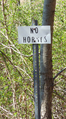
The No Horses Sign
It is not very obvious.
|
|
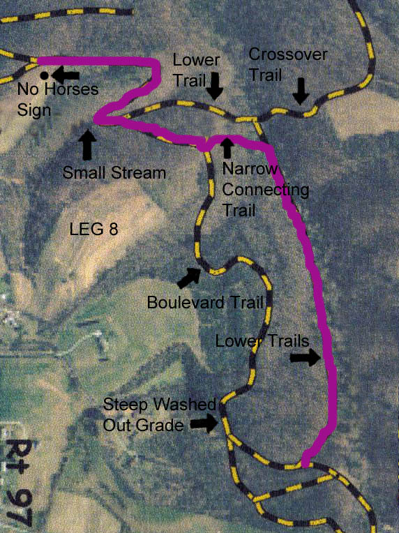
There is a third middle trail visible at this point just beyond the Crossover Trail, and we will make a slight bend to the right and then left and go onto it. At this point you are at a slightly washed out section of a trail that heads uphill. You first go uphill and then curve to the left and follow the trail down a little and then upwards to a point where it joins with the Boulevard Trail. This is the end of the network of the Lower Trails in the southern end of Union Mills Park. The junction of these two trails appears on the map as a distinct hairpin turn. You continue to climb uphill on the main Boulevard Trail, and at the top you turn left and continue uphill for another distance. At this point you are at the very top of the hill and in an oak forest. To your left is an opening into a field and a small sign reading No Horses. To your right is the opening of trail that runs down the hill and connects with a stretch I will mention in the future. It is marked Boulevard Trail North on the sign, but it is a narrow trail that I would not myself name as a Boulevard Trail. There is a second unmarked path leading down the hill in this area, which also connects with the trail that is down the hill. I will not take either of these at this point. I will end Leg Four here.
LEG FIVE
Leg Five Map
|
| 
|
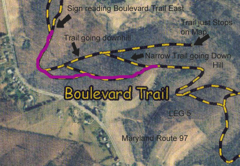
You will now continue on the main Boulevard Trail in an oak woods. The trail is wide and clearly was an old roadbed. It goes downhill from this point and continues on for a fair distance. Eventually you will come to a fork, and there are two trails here that are similar in size. Do not take the one to the right that goes downhill. This connects to a trail that I mentioned before as one that is a stretch I will mention in the future. Well, its still not the future, so you still have my promise to talk about this one and soon. Now, bear left here and follow the main trail that goes just a little uphill at this point. You will follow the main Boulevard Trail for a short distance, and then you come to a point where a fairly wide trail that enters from the right side and is coming up the hillside.
This is the head of the trail that I have promised to mention several times already. On the Carroll County Recreation Departments map of the Union Mills trails, this trail is shown heading east from this point in the direction of Big Pipe Creek but then just stops dead. I believe that the reason for this may be that the trail passes onto private land and is no longer part of the countys Union Mills Recreational Area or it may be that the map in incomplete. I will now pass by this trail and continue on the Boulevard Trail which is straight ahead. The Boulevard Trail makes a dip and curves to the right here. Route 97 is uphill through the woods and you might hear the sound of traffic. There is also a house back in the woods to your left. This is one of the few times at Union Mills that you are even aware of civilization. One nice thing about Union Mills is that you do not cross any major roads, and you are not that aware of human habitation. At last you come to a point where a trail joins the Boulevard Trail from the right side. There is a sign there indicating that this is Boulevard Trail East. I will end Leg Five at this point.
LEG SIX
Leg Six Map
|
|
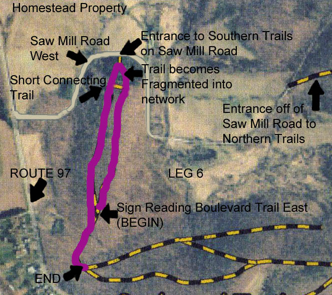
The name Boulevard Trail East is just a little misleading. In reality this is part of a looping trail that first does head east and slightly uphill from the main Boulevard Trail. However, it soon curves to the left and parallels the main trail. You turn onto this trail and ride downhill through an oak woods on a fairly wide trail. However, when you get towards the end of the trail it becomes confused. That is to say, the trail is about as confused as you are. There is a path to your left that runs a very short distance and back into the main Boulevard Trail. That may well be what is on the official trail map. However, you can pick your way farther north through a network of paths until you get to short stretch of trail lined by pine trees that passes left and around to meet the main Boulevard Trail near its origin on Saw Mill Road. All of these fragmented trails are on a hillside within sight of each other, and it is not possible to get lost in them. The trail has fragmented over the years from what was originally marked. Someone choose to rake out another foot path in this area which bisected the riding path, and soon riders used both paths accounting for the confusion.
When you encounter the main Boulevard Trail, it will be off to your left. Off to your right is a short downhill path that goes to the trailhead on West Saw Mill Road. There is nowhere here to park a horse trailer. To the north across West Saw Mill Road is the Union Mills Homestead property. This is managed by the Union Mills Homestead Foundation, Inc. I have heard rumors that there is a proposal to continue equestrian trails onto the Union Mills Homestead property, but I have no idea if there is really any serious consideration being given to this. The Union Mills Homestead was the home of the famous Shriver family. This is the family that gave us Sargent Shriver and Maria Shriver. During the American Civil War Confederate cavalry General J.E.B. Stuart stopped there on his way to Gettysburg and one of the Shriver boys volunteered to lead the Confederate cavalry north from here on their quest to find the main Confederate Army of R. E. Lee. So, you are riding in an area rich in history and equestrian history at that.
I should also mention that some riders either come or go from this exit and ride east down West Saw Mill Road. If you ever do this, be aware that you will need to cross Big Pipe Creek on a metal bridge that some horses have a hard time with. West Saw Mill Road does not carry a lot of traffic but it also does not have much in the way of a shoulder. Personally, I am happy to avoid any riding on public roads and am not necessarily suggesting that you do this.
The abandoned section of Saw Mill Road as it appears on an old road map in yellow. The central part at Big Pipe Creek in now gone but both ends are now equestrian trails.
|
|
|
|
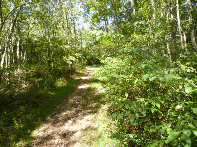
This is a wider section of trail, but where? I found all my pictures taken in the woods looked the same.
| |
However, if you ever do go on the road and over the bridge, eventually, you come to a place where there is another abandoned unpaved county road that dead ends on West Saw Mill Road and is marked as a trailhead for the county recreational area. This old road was part of the original Saw Mill Road but the county abandoned it and vehicular traffic continues on what is now called Kowomu Trail Road at this point. It is one of those odd and sudden changes in road names and if you did not know the story of the abandoned road you might wonder why the sudden change. If you turn in here and travel a distance down this old road you will come to the jumble of trails that are the northern section trails of the Union Mills County Recreational Area. I am not including them in my guide to the southern trails and suspect many first time visitors get lost in them. I hope in the future to do a separate guide to the northern trails. There are other ways to pass from the southern to the northern trails, so do not feel that you need to go this way.
Well, I have digressed and back to the Boulevard Trail and the southern trails of the Union Mills area. We were at the point where Boulevard Trail East turned into the main Boulevard Trail and the spot which is as far north as you can go on the southern trail network. We turn left and ride up the main Boulevard Trail heading south. We are still in an oak forest. We follow this trail past the entrance to Boulevard Trail East, now on our left and in time curve to our left and there is that entrance to the mysterious trail that I have mentioned several times and that goes nowhere if you look on our official map. I will end Leg Six here.
LEG SEVEN
Leg Seven Map
|
| 
|
Well, I am never one to pass up a mysterious trail and maybe that is why I have been lost more than a few times, but lets turns left and go down that trail. After riding a short distance down the trial there is on your right the inconspicuous opening to a trail we passed by earlier when riding along the Boulevard Trail. This trail, which we have not traveled, is odd because on one end it is a very wide trail that you might easily mistake for the continuation of the Boulevard Trail. However if you remember, I had you bear left and continue on what is really the Boulevard Trail. However, from this end the trail has become so narrow that you might totally miss it. Continue on past that opening on the main path. We are riding downhill along the hillside in woods. The trail is wide with a few eroded places. When we get toward the bottom there is a narrow trail to your right which comes down the hillside. We will turn into this trail, even though the wide trail continues on down the hill and to its mysterious rendezvous with the Bermuda triangle or whatever. You can see that the mysterious trail that we just turned off of branches just a short distance ahead. The upper branch is very wide and I suspect this is what the official map pictures as making a dead end. In reality it continues as a very narrow trail that loops back up the hill and connects with that unmarked path that was near the No Horses sign at the top of the hill. A second more narrow branch continues down the hill and this is the one that the map does not account for. Can I really spoil a good mystery? Returning to the point that I had you turn, I should say that the trail up the hillside from this point is very steep and very narrow and if you are in no mood for struggling up such a trail, I will understand if you retrace your steps back to the main Boulevard Trail heading the other direction on what I dubbed the mysterious trail, turn left on the main Boulevard Trail and I will meet you at the top of this cut. Okay, we climbed up the hillside on a narrow steep trail, our knees are not too banged up and we are back at the Boulevard Trail at the spot where there is that small No Horses sign on the edge of a field. I am glad that horses cannot read. I think that they would take all these no horses signs personally. They are such sensitive creatures.
LEG EIGHT
Leg Eight Map
|
|
You are now back on the main on the Boulevard Trail and headed downhill. At the end of this stretch you curve to the right and continue downhill until you curve left and reach a small stream that runs under in trail in a culvert. Once you turn there will be two trails. There is a trail coming uphill on your left marked with a Lower Trail sign. Previously, we had come out this way. This time we will ignore that trail and continue straight ahead and uphill on the main Boulevard Trail. Once you reach the top the trail levels out and then there is a dip. At the bottom of the dip is a narrow trail and runs down a draw between two hills. You will turn left onto this trail. If you would have continued on the Boulevard Trail you will come to that particularly steep and washed out grade that I have been trying to avoid. You might be forgiven if you think this stretch could use a little trail maintenance. So, next time they schedule a trail maintenance date here, we would love to have you. These trails are maintained by volunteers from the Carroll County Equestrian Council and also by a few other individuals on their own initiative. The county has limited resources and depends on volunteers to keep the trails going. However, it is a big job and the work is never-ending. When you come to the end of this stretch you intersect with the Lower Trails again and turn right. We will continue on the Lower Trails for a distance retracing are steps until we come to the crossing of the streamlet that I had mentioned before.
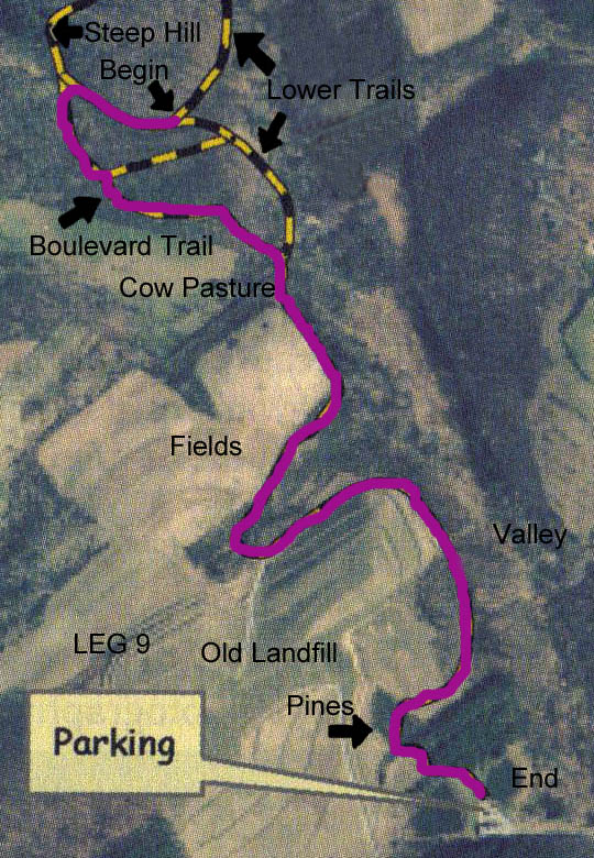
LEG NINE
Leg Nine Map
|
| 
|
We will turn right and retrace our steps along the connecting trail and the ditch and arrive at the Boulevard Trail. This time we will pass by the entrance of the parallel connecting trail located on the other side of the ditch and we will proceed up the Boulevard Trail. The trail is nice here and after a distance you hit a series of curves and begin to descend. Finally, you come to a fairly steep descent and you see the cow pasture to your right and the entrance to the Lower Trails to the left. There is a funny-looking lean to shelter in the pasture made of corrugated sheet metal. Go down this hill. It is not too bad a descent but take it slow until you reach the bottom and continue over the culvert and along the Boulevard Trail. From this point the trail climbs up a hill and then levels off. You curve to the left and to your right is the towering hill of the old Northern Land Fill. You go downhill and there may be some wet areas along here. At the end of the downhill trail you turn right and there are some multiflora rose and sticker bushes here on the right of the trail. Do not let them catch you. You are almost back to the parking area. You walk down a straight stretch. Down the hill is a steep path (no horses allowed) that goes down to the Bear Branch Nature Center and Hashawha. You follow the main trail around to the pine woods and then curve left and there is the parking area.
I hope that you were able to do this without getting lost or confused. However, getting lost and confused at a new place is part of trail riding and our challenge is to take a deep breath and figure out what to do. If you are lucky you might meet another rider or hiker but Union Mills is a big place and we often encounter no one our entire ride. There are few landmarks in the middle of a woods that you can orient on. If you are on a wide trail in this area that appears like a gravel county road or lane, you can bet that it is the Boulevard Trail. If you are on a narrow but well-worn path on a hillside, you can be certain that you are on the Lower Trail. Occasionally, riding groups sponsor organized guide rides at Union Mills, but I suspect none of them leave from the southern parking area. Have a great ride and be safe.
Yours truly,
The Accidental Horseman.
Carroll County Equestrian Council's Web Site
Virtual Tour of Morgan Run, South of Westminster, MD
Virtual Tour of Codorus, South of Hanover, PA
Gettysburg on Horseback
Back to Additional Discussions
Links to Other Sites regarding Horses
Back to Index Page